
Choptank Riverkeeper
The Choptank Riverkeeper works to protect and restore the waterways and tributaries of the Choptank River, including the Tuckahoe River, Harris Creek, Broad Creek, and the Tred Avon River.

The largest of the Chesapeake’s Eastern Shore rivers, the Choptank winds for 68 miles from its non-tidal, freshwater beginnings in Delaware and Caroline County, Maryland to its brackish mouth, over a mile wide, spanning from the tip of Tilghman Island in Talbot County to the southern crook of Cook Point in Dorchester County.
Culturally, it has been stated that “no river in the Chesapeake region has done more to shape the character and society of the Eastern Shore than the Choptank” (Maryland Department of Natural Resources.) The Choptank was a major contributor to Harriet Tubman’s many journeys north navigating the underground railroad to freedom. The river was an essential conduit for local farmers to receive tools and resources and for the many canneries to export products first via sail and later via steamboat. The river’s rich seafood diversity made it a destination for fisherman and supported one of the largest commercial fishing industries on the Bay.
Wild and isolated in part, bordered by marsh in some places, by old-growth forests in others, mother to countless smaller rivers, coves, and creeks, home to an amazing abundance and diversity of life, the Choptank, nonetheless, is out of balance — excessive nutrients from fertilizers and animal waste have led to too much nitrogen and phosphorous in the river, leading to algae growth, clouded water, dying grass beds, and insufficient oxygen for aquatic life.
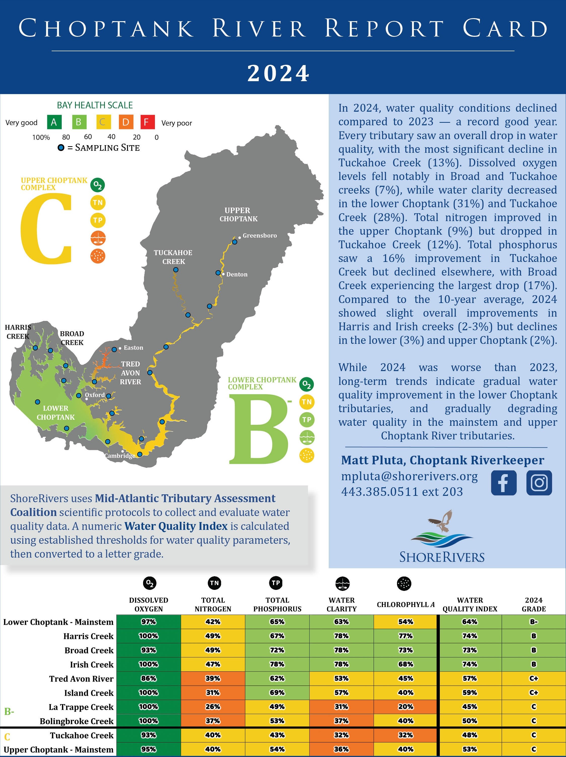
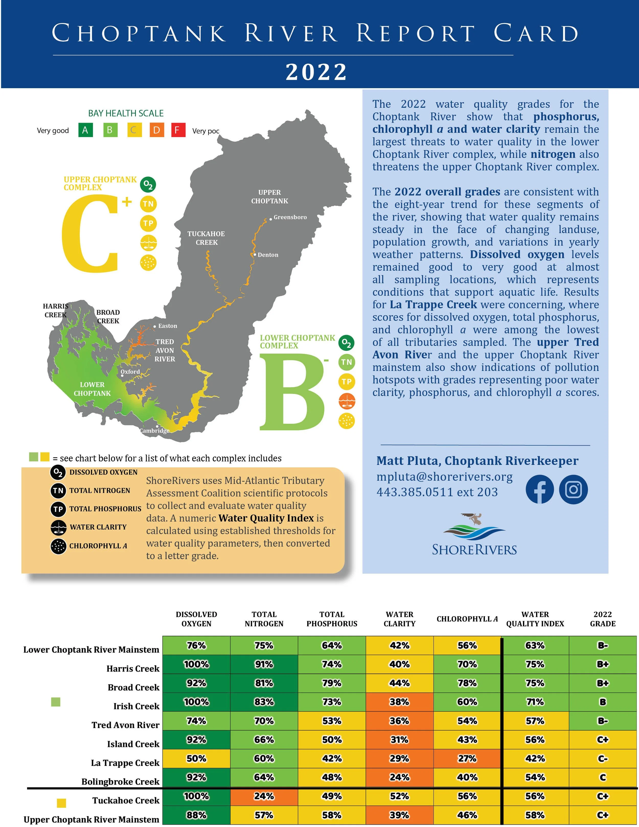
The Choptank Riverkeeper and our network of citizen science volunteers monitor water quality at nearly 50 locations throughout the tidal portion of the river. Year after year these data conclusively show that the water adjacent to our towns and in the Upper Choptank is more degraded than water downriver. The nutrient and sediment pollution impacting our river is coming from the land that surrounds us, which fortunately provides an opportunity for restoration and protection.
Our different efforts to reduce pollution reflect the different characteristics displayed by this river throughout its nearly 1,000 square mile watershed. The narrow stretches of the Upper Choptank are mostly impacted by the dominant surrounding landuse of row crop agriculture. Thus, our strategy to reduce pollution is to work with our farmers and landowners to manage nutrients and sediments on the land before they reach the river.
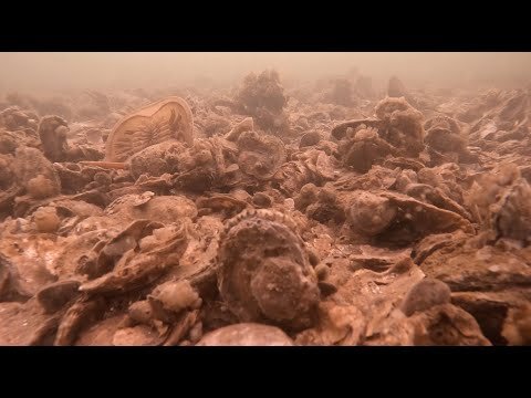
Conversely, the vast, wide-open Lower Choptank frequently flushes with water from the Chesapeake Bay, requiring a different approach to pollution reduction. Here we’re working with our waterfront towns to manage runoff and wastewater systems, but we’re also focusing on improving and protecting habitat — building oyster reefs, planting underwater grasses, and creating conditions that are inviting to the many ecologically important species that seasonally spawn in the river or call the river home year-around.
ShoreRivers and the Choptank Riverkeeper are working to reverse decades of declining water quality in the Choptank. In recent years we have seen a resurgence of grass beds, improved water clarity, thriving oyster sanctuaries, and many other encouraging signs that the river is responding. There is more to do, of course. But in concert with our communities, ShoreRivers will relentlessly pursue its vision of a healthy, restored, and protected Choptank River.
Choptank Videos

Technical Documents